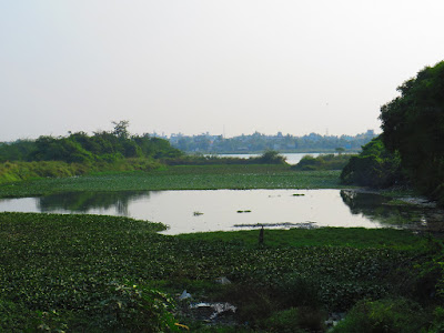
Perumbakkam Lake (Waterbodies of Chennai - 53)
Perumbakkam Lake spreads over 200 acres. It is the water source for the farmers of Perumbakkam and the adjoining villages. Thanks to urbanization, those villages are getting quickly converted into the city. Before one decade, the situation was pretty good. Although no effort appears to have been taken up by the authorities to maintain it, the lake remained beautiful and untouched. Due to the mushroom growth of real estate in this area, there are encroachments. Also, dumping of garbage into the lake and water hyacinth are slowly killing the lake.
Only a few know that the hills on the other side of the lake have some historical significance. The Great Trigonometrical Survey of India started in Madras. Major William Lambton began this project on 10th April 1802 He had selected the flat plains with St. Thomas Mount at the northern end, which is well known and much talked about. He had set Perumbakkam hill at the southern end, a lesser-known fact.
Happy travelling.
Note: As per a report, there were about 650+ waterbodies in the Chennai region till the 1980s. Today, only a fraction of them exist. And most of those surviving waterbodies hardly have water, and even some of them that have water have been poorly shrunk. In Chennai, there are tank roads without tanks nearby and lake-view roads without lakes. There is a high possibility that even the few waterbodies we have today might vanish soon. I decided to visit the currently surviving waterbodies of Chennai and its suburbs and write about them in my blog as a series.


.JPG)
Comments
Post a Comment